The arrival of spring means the ground finally thaws, the birds chirp again, and the trees form their buds. As the weather warms up, more opportunities arise to get outside and enjoy the fresh air. Red Wing and its surrounding area offer plenty of beautiful hiking spots where you can take in the natural beauty of Minnesota and get a great workout. Read on to learn about the top hiking locations to check out this spring as the weather finally warms.
Afton State Park Hiking Club Trail
If you’re a less seasoned hiker, you may want to try hiking the Afton State Park Hiking Club Trail located in Afton State Park in nearby Hastings. In addition to hiking, the park is a popular spot for campers, swimmers, and fishers. The hiking club trail is one of the park’s more popular trails, stretching 2.5 miles.
Hikers begin the trail by entering a restored prairie loop, found near the visitor’s center. Along the way, you can enjoy taking in the park’s lush natural surroundings as you hike up the hilly, grassy trail. You may want to break out the sunscreen or wear a hat if it’s an especially bright day. This trail also feeds off into some of the park’s many other trails, so you can extend your hike for as long as you like.
Barn Bluff Trail
Barn Bluff Trail is popular among rock-climbers, bird watchers, and hikers alike, and it’s easy to see why. The trail is known for being one of the most scenic hiking spots near Red Wing. The two-mile climb is steep but steady, with several sets of steps to climb up.
As you’re climbing, you can explore the flora and fauna of the forest and soak in the smell of nature. The south side contains a light smattering of tall trees, while the north side consists of thicker, denser woods and rockier spots. Regardless of which trail side you choose, you’ll be greeted by scenic overlooks offering majestic views of the surrounding area. The 340-foot bluff overlooks the Mississippi and the serene countryside of both Minnesota and Wisconsin. You can also enjoy a bird’s-eye view of Red Wing’s historic downtown. Be sure to watch for loose or falling rocks as you climb.
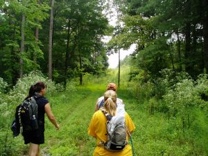
Bluffside Trail
Just a short ride south of Red Wing sits Frontenac State Park, featuring a variety of campsites, ski slopes, and bird-watching spots. The park’s 2.9-mile Bluffside Trail is especially perfect for springtime hiking, offering hikers the chance to see a variety of waterfowl, including loons, pelicans, and the occasional swan. Hikers can enjoy beautiful views of the Mississippi at the end of the trail and walk over varying levels of stairs. Watch out for steep inclines and jutting rocks as you hike. If you’re a less seasoned hiker, you may want to bring a hiking stick for extra help.
Cannon Valley Trail
The Cannon Valley Trail follows the majestic Cannon River and has become a multi-use trail, attracting hikers, cyclists, and skateboards alike. The 19.7-mile trail connects the cities of Cannon Falls, Welch, and Red Wing and showcases some of southeastern Minnesota’s best scenery. Gradually descending 115 feet in elevation from Cannon Falls to Red Wing, the trail offers unique, unparalleled views of the valley below. In the spring, the views become especially appealing as the trees begin to turn green and flowers bloom all around the ground.
As you wind through thick, deciduous forest, unique plants native to Minnesota, and rocky limestone cliffs, be on the lookout for bald eagles, beavers, and red foxes. Restrooms are accessible in Cannon Falls, Anderson Memorial Rest Area, Welch Station, Old West Main Street, and Bay Point Park in Red Wing. Pets are not allowed on the trail. The Welch Station trailhead is the midpoint, with an option to go west back towards Cannon Falls if you don’t want to carry on the hike.
Hay Creek Trails
Red Wing is nestled in hills, so it’s easy to gain elevation quickly without having to walk too far. The Hay Creek Trails aren’t much different, with plenty of scenic spots overlooking a variety of terrain. The primary trail reaches close to 300 feet in elevation before sharply descending back down toward the parking lot. Hay Creek itself is an excellent fly-fishing spot, so don’t forget to bring your rod to fish in the trout stream.
The dense, rugged forest teeming with wildlife and views of the sparsely populated valley help add to the feeling of quietness and relative remoteness. Should you choose to hike in the early morning, keep your ears tuned for the sound of wild turkeys gobbling about and birds chirping to one another as they dig in the soft grass for worms. The trail also has a decent picnic area to settle down if you’re planning on having lunch before or after your hike.
Sorins Bluff Trail
Sorins Bluff Trail is located at Memorial Park and offers plenty of scenic views of Red Wing and its community. Sorins Bluff features a variety of trails of different lengths that go through prairies and wooded areas, and less seasoned hikers can stick to the less strenuous trails. Guided hikes may also be offered during the later months of the spring and throughout the summer. If you’re hiking Sorins Bluff, you might also want to enjoy Memorial Park. The park has several picnic tables, charcoal grills for pre-summer barbecues, open grassy areas, and a nine-hole Frisbee golf course.
Red Wing and the surrounding area have plenty of excellent spring hiking spots. From short, grassy trails to long, windy, steep trails, Red Wing has it all. Our team at Tom Kadlec Kia hopes you enjoyed this list of some of the most scenic hiking spots in the local area. Did we miss your favorite hiking spot? If we did, let us know by filling out our contact form, and we’ll be happy to check out your ideas and add them to our list.
Connect with us


Recent Blog Entries
Categories
 Warranties include 10-year/100,000-mile powertrain and 5-year/60,000-mile basic. All warranties and roadside assistance are limited. See retailer for warranty details.